BostonHarborwalk.org was designed to help folks find and navigate the Harborwalk and the many public benefits available along it that have been secured by a state law called Chapter 91. This law states that all non-water-dependent development along the harbor must have a set of public amenities. Want to go for a waterfront walk, find the nearest public restroom, or enjoy a rooftop view of the harbor? Use the tool to find what you need along the Boston Harbor shoreline.
Navigating the map on a desktop/laptop
Visit https://www.bostonharborwalk.org/ to use webtool on your internet browser. It should look like this.
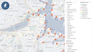
The orange pins indicate a specific area on the map that represents a Chapter 91 license. The pins with numbers represent clusters of pins in the same area. You will need to zoom in to view the additional pins.
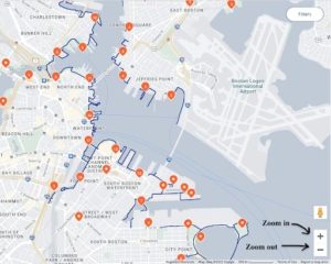
To zoom in and out, you can use the CTRL key and your mouse to change the zoom. Alternatively, click the “Hide Filters” button and then use + and – on the lower right-hand corner of the screen to zoom in (+) and out (-). Or you can use your keyboard to zoom-in and look at the map in more detail, to do this simultaneously push the “Shift” key and the “+” key at the same time. To use the zoom-out feature just push the “-” key.
To drag the map around within the frame, click on the screen where the map is and while keeping your finger on the touchpad or mouse, drag your finger around the touchpad and the map on the screen will move with your finger.
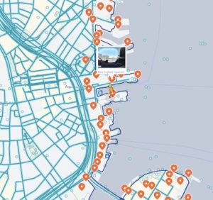
To access street view, click and drag the yellow figure (found on the bottom right corner) to the area you wish to view. When you click and drag the figure, most of the streets within the frame will turn light blue. Just drop the yellow figure (lift your finger from the touchpad or mouse) onto any light blue line to view that area as if you are on that street in person (see below).
Navigating the map on a smartphone:
Open a web browser and search https://www.bostonharborwalk.org. It should look like this.
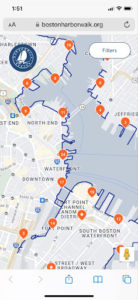
The orange pins with numbers represent clusters of pins in the same area. You will need to zoom in to view the additional pins.
To zoom in and out on the phone, use the + (to zoom in) and – (to zoom out) buttons on the bottom right corner of your screen or move your fingers close together to zoom out and move your fingers further apart to move in.
To drag the map around within the frame, use two fingers at the same time and drag them both around on the screen to bring the specific areas you want to look at into the frame.
To access the street view, tap and drag the yellow figure (found on the bottom right corner) to the area you wish to view. When you tap and drag the figure, most of the streets within the frame will turn light blue. Just drop the yellow figure (lift your finger from the screen) onto any light blue line to view that area as if you are on that street in person.
Find Public Amenities Along the Waterfront
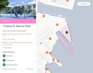
To learn more about a specific place on the map while using a desktop or laptop, click on individual orange pins to view the location information and the public amenities available there. For each location, there will be a picture, contact information, and a list of the public amenities required by the site’s Chapter 91 license. For some public amenities, there are drop-down arrows that give more information or directions to specific amenities, like directions to find the water taxi dock.
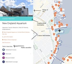
Once you click on a pin it will turn black indicating it has already been clicked.
Between the photograph and the site name, there is a color bar for that neighborhood. Click on the drop-down arrow to find out more information about that neighborhood.
To find a certain kind of public amenity, use the filter feature . Click the “Filters” button in the top right corner of the screen, then select one or more public amenities available along the waterfront. You can do this by clicking the symbol next to the amenities you wish to see. When you click the symbol it will change color and several orange pins will appear across the map indicating where that amenity is available. Click on a pin to learn more about a particular waterfront property and its public amenities. To clear all filters tap the “Reset Filters” button at the bottom of the screen under “Amenities.”
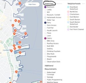
To filter search by neighborhoods, go to the “Filters” tab and under “Neighborhoods,” click the specific neighborhood(s) you wish to explore. All the pins for that neighborhood will appear. You can filter multiple amenities and neighborhoods at the same time.
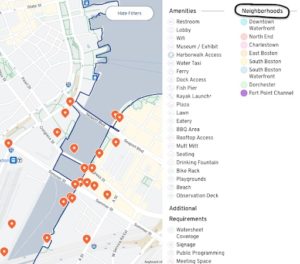
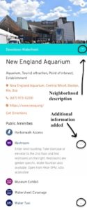
To view amenities on a smartphone, tap on individual orange pins to view the location information and the public amenities available there. For each location, there will be a picture, contact information, and a list of the public amenities required by the site’s Chapter 91 license. For some public amenities, there are drop-down arrows that give more information or directions to specific amenities, like directions to find the water taxi dock.
Between the photograph and the site name, there is a color bar for that neighborhood. Click on the drop-down arrow to find out more information about that neighborhood. Once you click on a pin it will turn black indicating it has already been clicked.
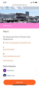
To find a certain kind of public amenity, use the filter feature. Tap the “Filters” button in the top right corner of the screen, then select one or more public amenities available along the waterfront. You can do this by clicking the symbol next to the amenities you wish to see. When you click the symbol it will change color. Select the specific amenities you wish to search for and then tap “See Results” in the top right corner. Several orange pins will appear across the map indicating where that amenity is available. Click on a pin to learn more about a particular waterfront property and its public amenities. To clear all filters tap the “Reset Filters” button at the bottom of the screen.
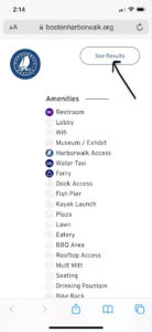
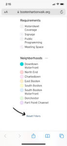
To filter search by neighborhoods, go to the “Filters” tab, scroll down to “Neighborhoods,” and tap the specific neighborhood(s) you wish to explore. All the pins for that neighborhood will appear. You can filter multiple amenities and neighborhoods at the same time.
Other features of the webtool
Property boundaries: The Harborwalk was created by different private and public property owners. To understand how property lines might affect the changes in the building materials of the Harborwalk path or the availability of public amenities, the map shows information about each parcel. The highlighted or shaded areas on the map illustrate the boundaries of a parcel of land or property associated with a particular building, park, or development.
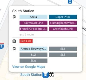
Public Transportation: To find public transportation routes around particular locations, look on the map for either a bus, train, or ferry symbol. When you click on the symbol, it will indicate the public transportation lines available at each location.
Bus symbol ![]()
Train symbol ![]()
Ferry symbol ![]()
Chapter 91 licenses. For each site, at the bottom of the screen it will say “Chapter 91 license details.” Clicking this link will redirect you to the MassDEP website with a map of the Chapter 91 licenses. These legal documents describe the public amenities agreed to by owners for all non-water-dependent development along the harbor.
Getting non-emergency help through BOS: 311. 311 connects you with City representatives who are ready to help with requests for non-emergency City services and information. For more information about BOS: 311 click here.
For more information: Scroll to the bottom to view the Harborwalk Webtool Blog, About page, Contact page, Terms, or Subscribe to get email updates.
